Aug 9, 2009

Aboard Pirata

La Pirata
After returning soaked, boots and all, from Caleta Iguana, there was time for reflection as we sailed past Cerra Azul volcano and out of the clutches of the garua. It would take days to dry out our clothes. Falk didn’t even make the attempt. On the way back to Pirata in the panga, he quietly set his socks free in the ocean. The day’s work could be considered a miserable experience. So could yesterday’s. Not everyone would enjoy this. We had to be resilient, problem solvers at every station. We faced variables at every landing site. Nothing ever went exactly to plan. That is the nature of field work. Those were some of my fleeting thoughts. But, as we approached the sunshine, it was the compensating factors, sunrises, sunsets, active volcanoes, marine iguanas, penguins, sea turtles… that came to mind. And, as scientists, we are answering important questions. There is excitement in that.

Some of the biggest compensating factors on this field excursion have proved to be the Pirata and her crew. They earned our respect by carefully stowing all of the awkward geophysical gear for our ocean voyage. They demonstrated their seamanship by keeping us safe on the open ocean and skillfully guiding us to our landing sites. We ate well and slept well. Most importantly, onboard we became part of the culture of the Galapagos. Both the ship and crew are natives.

The story of the Pirata is best told by the photos. It is, however, worth putting this image into words. It is Elizabeth Bay, where you can sit on the deck while the suns sets and listen to the bark of sea lions. Just by turning your head you see five active volcanoes, Fernandina, Cerra Azul, Sierra Negra, Alcedo and Darwin. For me that was the Galápagos.

Scientific Team

Scientific Party

The scientific team for Collaborative Research: An integrated seismic-geodetic study of active magmatic processes at Sierra Negra volcano,Galápagos Islands assembled in Puerto Villamil, Isabela Island, Galapagos, Ecuador. We represented two countries, three geoscientific disciplines and teaching. Some of us spoke Spanish and English and some spoke only one or the other. During the time span of July 24 to August 1, 2009, we collaborated to install sixteen seismic sensors around Sierra Negra volcano.

Aug 8, 2009

Vulcan Sierra Negra

Sierra Negra

On July 28, 2009, the Boat Crew had its first opportunity to climb and see Vulcan Sierra Negra,Isla Isabela, Galapagos. The Volcano Crew had already made the twelve mile round trip four times. Today, we would accompany Dennis Geist, volcanologist, as tourists to learn about the 2005 eruption. Dennis was taking advantage of a rare opportunity. He would meet a private helicopter on the crater rim to transport seismic station equipment from the rim to the center of the crater floor. The volcano crew would still have to hike out through the treacherous aa to install the station and make it operational, but they would not have to carry the heavy equipment, just water. If we could keep up with Dennis on the muddy trail, this promised to be an exceptionally fine day.

As we hiked quickly through fog, mist and mud (we were in the garua again), we were concentrating on not slipping and thinking of the newly installed array of seismic sensors gathering data from local and regional earthquakes. Those sensors will soon provide new data to integrate with the continuous GPS and InSAR data. On the spot volcano monitoring, continuous GPS and InSAR data have provided a wealth of information about how the surface of the volcano changes and deforms. That data has been used to model the magma chamber underlying Sierra Negra’s crater, but there are two magma chamber models that can explain the deformation at the surface. Seismic data will allow geoscientists to distinguish between them. We were ready to see that surface deformation for ourselves. We broke through the mist. The mud dried, and we looked down into the crater 9 x 7 km crater. Although we walked along the rim for most of the day we were never able to see across the caldera. Our far horizon was "the sinuous ridge", a distinctive fault scarp about two thirds of the way across the caldera. From our lunch stop we could clearly see the flows from the 2005 eruption and the channels which funneled lava across the floor of the crater from the vent site on the northeast rim. Denny described curtains of fire that had marked the channels of flowing lava, and how the caldera floor inflated prior to the eruption. He pointed out the area where lava had ponded before flowing out along two channels. While vents formed along the northeast rim, to the southeast, the crater floor subsided along a fault known as "the sinuous ridge." This fault acted like a trapdoor and the southwest side of the crater dropped. As we continued along the rim,a smooth looking coating of tephra crunched beneath our feet(hear video). To the northeast we could see Elizabeth Bay and pick out most of the Boat Crew’s installation sites.

We returned from the vents just in time to record the arrival of the helicopter and witness Dennis’ flight to the caldera floor. After an excellent day on the volcano, he led us back down into the garua.

Aug 7, 2009

Seismic Stations

Seismic Stations
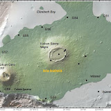
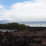
For most of us the introduction to seismic station installation began in earnest at 9:00 am on Thursday, July 23. We loaded the Panga, our launch, as fast and efficiently as possible, while it bobbed in the ocean. No wet feet this time as we jumped out and passed equipment in a chain across pahoehoe. We loaded up quickly and began scouting for a setup location. The sensor had to be in a stable, safe and level position. Without realizing it, we started to settle into what would become our regular jobs. I was a recordkeeper. I used the handheld GPS to mark our landing site, station site and the path in between. I checked off each step of the setup procedure, recorded start up data, kept field notes and used my compass to orient the sensor. Falk became an expert at choosing sites, assembling the solar panel setup and carrying the delicate, heavy sensor. Eliana, and Cindy for the volcano group, were the experienced seismologists and set up experts. For the first two stations, with five of us, the process went smoothly. It took a little over an hour per station and about two hours of sailing time between stations. At GS02 we practiced our barefoot landing skills on a stony beach of rounded basalt pebbles the size of brussel sprouts. My feet were not ready, and I learned that “barefoot landing” meant wear your Tevas. At GS02, the lava was not quite pahoehoe and not quite aa. The flows were broken into large chunks with smooth, ropy tops. It was beautiful. The glassy swirls and bubbles of pahoehoe broke into crinkly spikes, like iguana crests on the edges of the aa-like chunks. Going was tougher, and we learned to wear long sleeves and pants. The importance of carefully choosing a landing site on pahoehoe became clear. Luckily, Captain Lenin understood this as well. With two stations installed, we sailed for Puerto Villamil.

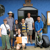
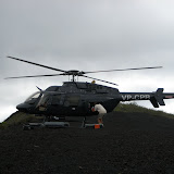
Villamil,Isla Isabela, Galapagos, became the homeport for the Volcano Crew. We assembled in the rain at the Darwin Center office and met Mario Ruiz and Daniel Pacheco, our Ecuadoran colleagues. Then we quickly divided up and went our separate ways. The Boat Crew had six more stations to install, and the Volcano Crew had eight. We had gained Daniel for the boat. Mario headed up the volcano with Cindy and Dennis. Each group faced some uncertainty and risk, traveling by boat, horseback, truck and foot through mud and lava. Aboard Pirata, our first challenge was seasickness (see video).

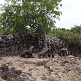
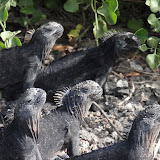
Each seismic station was different, challenging and beautiful in its own way. We were on an adventure in the Galápagos. At Installation Site GS03, our landing was dependent on the tide. We loaded the panga and surfed through a tiny opening into a cove filled with sea turtles. At GS04, Elizabeth Bay, the panga drifted carefully along a narrow channel to a tiny pool filled with sea lions and sea turtles. On the way out we swam alongside the panga with the sea lions. At GS05, we finished at sunset and faced the possibility of navigating through a lava field with our Petzel headlamps. In near dark, the Panga guided us back just a few feet from rocks covered with penguins, flightless cormorants, sea lions, iguanas and crabs settling down together for the night. They must know they are the tops of the food chain. Fish beware! At dawn we watched the same predators slip off the rocks to find breakfast. GS06 took hours and provided us with an experience that earns a separate description (see Geophysicists and Geologists). But, there was still time to install station GS07 on a narrow arc of pahoehoe surrounded by a sea of treacherous aa, and for some photos of penguins at dusk. On July 27, our panga brought us to Caleta Iguana at the western tip of Cerra Azul Volcano for GS08. Passing a white shrine to the Virgin Mary,we entered another tiny cove filled with sea turtles. Already rain soaked, we climbed and passed from the bobbing panga up, onto a cement dock. The rainy mist, garua, and lack of lava made Caleta Iguana mysterious, as did the poisonous trees. We knew that the biggest trees were the ones we shouldn’t touch. But, surrounded by a jungle of unknown bushes and trees, we were apprehensive. Donning red wool gloves, we scrambled into the mist and pouring rain. We trekked along a tortoise’s trails to locate station GS08. When we encountered him he didn’t seem pleased. We were so wet and busy that we didn’t have time to take a picture of our first wild tortoise, but I later got one of his scat. With the last of our seismic equipment installed, we shooed a sea lion from the dock and returned to the Pirata. It took hours to sail away from the garua and into the sunshine.

The Boat Crew had completed its mission. We had shared experiences and become a team. After a hike up Sierra Negra, Eliana and I returned to our other lives. Falk and Daniel joined the Volcano Crew and had further adventures.

Aug 5, 2009

Geophysicists and Geologists

Geologists and Geophysicists

On the boat crew there were four geoscientists, two geophysicists and two geologists. For this part of the experiment, installing seismic stations, the geophysicists were in charge. As we lugged geophysical equipment over the crunchy pahoehoe at Station GS06, there was some friendly banter about why Daniel, a geologist, persisted in carrying his rock hammer at every stop. The short answer is, “qualitative vs. quantitative.” Qualitative versus quantitative analysis of rocks and the Earth is one way to distinguish a geologist from a geophysicist, but it applies only in the field. Geologists use qualitative scientific skills, observation and documentation, to describe rocks, outcrops, volcanic eruptions, and to choose samples for analysis. They are often able to travel light, wearing a field vest stuffed with compass, GPS, map, hand lens, field book and of course a rock hammer. Their quantitative analysis takes place back in the lab. In contrast, Geophysicists are conducting quantitative analysis from the get go, and they do not travel light. Sensors, computers and power sources accompany them every step of the way. They are catching the waves, light waves, sound waves, water waves or seismic waves. Catching invisible waves requires equipment. Of course this is an oversimplification. But this topic did come up in the field, and circumstances answered the question, “What is the collaborative relationship between a geologist and a geophysicist? “

Seismic Station GS06 proved a challenging installation. It took an hour of reconnaissance just to choose the site, on a ledge next to a relatively deep crevice. It was safe and remote, but repeatedly stepping across the crevice while we worked was disconcerting. We had trouble with the sensor and Falk returned to the ship to exchange for another one. Time passed. Black lava gets hot in the equatorial sun, and lovely, crunchy swirls of pahoehoe are glassy and sharp against your arms and knees. By the time our work was finished, we were hot, tired and wearing small red badges of courage awarded by the sharp lava. We gathered the empty containers, tools and supplies and crossed the crevice for the last time. And the small portable computer, a Clié, fell into the crack. The bonds of friendship and concern for safety kept us calm, but it was a tense moment. We could see it, but no one could reach it safely. Our first attempt at recovery naturally involved duct tape. Daniel attached a big wad to the end of an unused aluminum part of the solar panel mount. No luck. He could touch it, but it was too heavy to stick. Eliana, from halfway into the crack said, “If we had something with an L shape or a right angle, perhaps we could hook the strap.” What she meant was, “We need a geologist with a rock hammer.” It only took a second for me to grab Daniel’s. Duct tape secured it to the aluminum. Eliana hooked the Clié on the second try. We had all learned an important lesson about geosciences and collaboration.

Every geophysicist needs a geologist for a friend and vice versa.

Aug 4, 2009

Time for Tortoises

Time for Tortoises
Just a hundred yard dash away from the storage room where we were conducting the Huddle Test, the famous tortoises of the Galapagos were living and growing. The first day, we were too busy sorting through geophysical equipment to give them a second thought. The second day was a different story. All of my students know that I have a particular fondness for turtles and tortoises. I slipped away to see the small tortoises.

The Giant Tortoises of the Galapagos were hunted almost to extinction by humans. They were easy to catch and an excellent food source for sailors on long voyages. Today they are protected from humans but face threats and competition from introduced species like rats, and feral goats and pigs. So, baby tortoises are raised at the Darwin Research Center for about five years. When they are large enough to be safe from predators, they are repatriated to their native islands. As we were siting our final seismic station at Caleta Iguana on the south flank of Cera Azul volcano, we watched the Galapagos Park Service load tortoises onto a helicopter for the trip back to their native volcano. On this day, I spent a few moments with a tour group watching the young tortoises, each with a number painted on its back. Then, I tried to hurry back to the work group and accidentally took a wrong path. I ended up peaking over a wooden fence just as the Giant Tortoises were waking up and stretching for the new day. When they saw me, three of them seem to strike a pose on their rock, stretching their necks for my camera.

The mission of the Charles Darwin Foundation is to ensure the conservation of the environment and biodiversity in the Galapagos Archipelago by providing knowledge and assistance through scientific research. For the three days that we were in and out of the Darwin Research Center organizing and preparing for our expedition we observed a steady stream of tourists from all over the world visiting the Center to learn about biodiversity, conservation and the endemic species of the Galapagos. This is the first stop for all tour groups. The education one receives here enriches the experience of traveling through the islands and also helps to slow the introduction of invasive species to this unique place.

But, in case education isn’t enough, all of our luggage and equipment spent an entire day in quarantine. Each and every piece of clothing we had was examined and checked for seeds, dirt and insects. Everything was placed in a special room and sprayed with insecticide. We wouldn’t be transporting even one mosquito to Isla Isabela.

Links to more information about conservation in the Galapagos:
Charles Darwin Foundation http://www.darwinfoundation.org/english/pages/index.php
Galapagos Conservancy http://www.galapagos.org/2008/index.php
Galapagos Conservation Trust http://www.gct.org/index.html
Galapagos National Park http://www.galapagosonline.com/Galapagos_Natural_History/National_Park/National_Park.html

Aug 3, 2009

Arrival and The Huddle Test

Arrival and The Huddle Test

After a last minute flurry of e-mails, planning, packing, and repacking, we were ready. The equipment had been shipped ahead. Five of the seven scientists met at the Darwin Research Center in the town of Puerto Ayora, Santa Cruz Island, Galapagos, Ecuador on Monday, July 20. There we tested the equipment in “The Huddle.” Next, we traveled together, with the equipment, overnight by ship to Puerto Villamil on the Island of Isabela. There, after meeting two Ecuadoran geoscientists, our scientific party was complete. From that point we split into two groups. The “ship crew” traveled by sea, landing by launch, setting up seismic stations around the perimeter of Isabela Island. The “volcano crew” trekked by foot, horseback and helicopter transporting the heavy, delicate equipment to station sites around and within Sierra Negra Volcano.

It sounds simple. The reality was science and adventure that required collaboration, teamwork and use of all of our scientific skills.

In order to effectively hit the ground running when we arrived at the Darwin Research Center we built an extra travel day into our schedule. Scientists for this project were arriving from Rochester, NY, Socorro, NM, San Francisco, CA, Moscow, ID via London, Miami, FL and Quito, Ecuador. Four of us spent a Sunday afternoon, along with hundreds of proud local families, strolling along the Maleçon de Simon Bolivar. The last leg of our journey involved a plane, bus, ferry and taxi. We had just enough time to change clothes and then we were in The Huddle. Eliana Arias-Dotson, geophysicist and data specialist from Iris Passcal, gave instructions for the process and then, whatever our individual level of experience, we got to work. Although in the field there are usually three or four people, everyone had to learn the process of setting up a seismic station. Sixteen complete stations had to be unpacked, assembled and left running overnight as a test. By 8:30 pm, amidst a sea of wires, everything was working. Next morning all of the stations had to be disassembled and repacked for the trip to the field. There were also specific supplies like plastic storage containers, trash bags and solar panel mounts that had to be purchased or constructed for the unique characteristics of work in the Galapagos. At 3:00 pm our luggage and all equipment went into quarantine. We had to ensure that we were not transporting invasive species to pristine Isla Isabela. Our stroll along Maleçon de Simon Bolivar seemed far in the past.

Afternoon, July 22, we recovered everything from quarantine, loaded it aboard a water taxi for transport to the Ship Pirata. Overnight, a heavily loaded Pirata transported us to Isla Isabela. We awoke at the site of our first station, GS01.