 |
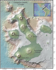
| Sierra Negra |
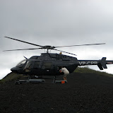
On July 28, 2009, the Boat Crew had its first opportunity to climb and see Vulcan Sierra Negra,Isla Isabela, Galapagos. The Volcano Crew had already made the twelve mile round trip four times. Today, we would accompany Dennis Geist, volcanologist, as tourists to learn about the 2005 eruption. Dennis was taking advantage of a rare opportunity. He would meet a private helicopter on the crater rim to transport seismic station equipment from the rim to the center of the crater floor. The volcano crew would still have to hike out through the treacherous aa to install the station and make it operational, but they would not have to carry the heavy equipment, just water. If we could keep up with Dennis on the muddy trail, this promised to be an exceptionally fine day.
As we hiked quickly through fog, mist and mud (we were in the garua again), we were concentrating on not slipping and thinking of the newly installed array of seismic sensors gathering data from local and regional earthquakes. Those sensors will soon provide new data to integrate with the continuous GPS and InSAR data. On the spot volcano monitoring, continuous GPS and InSAR data have provided a wealth of information about how the surface of the volcano changes and deforms. That data has been used to model the magma chamber underlying Sierra Negra’s crater, but there are two magma chamber models that can explain the deformation at the surface. Seismic data will allow geoscientists to distinguish between them. We were ready to see that surface deformation for ourselves. We broke through the mist. The mud dried, and we looked down into the crater 9 x 7 km crater. Although we walked along the rim for most of the day we were never able to see across the caldera. Our far horizon was "the sinuous ridge", a distinctive fault scarp about two thirds of the way across the caldera. From our lunch stop we could clearly see the flows from the 2005 eruption and the channels which funneled lava across the floor of the crater from the vent site on the northeast rim. Denny described curtains of fire that had marked the channels of flowing lava, and how the caldera floor inflated prior to the eruption. He pointed out the area where lava had ponded before flowing out along two channels. While vents formed along the northeast rim, to the southeast, the crater floor subsided along a fault known as "the sinuous ridge." This fault acted like a trapdoor and the southwest side of the crater dropped. As we continued along the rim,a smooth looking coating of tephra crunched beneath our feet(hear video). To the northeast we could see Elizabeth Bay and pick out most of the Boat Crew’s installation sites.
We returned from the vents just in time to record the arrival of the helicopter and witness Dennis’ flight to the caldera floor. After an excellent day on the volcano, he led us back down into the garua.